JACKSONVILLE, Fla. — To become a part of the First Alert Neighborhood weather station network powered by Tempest - scan below &/or click * here *:

Updated every day throughout the hurricane season - “Talking the Tropics With Mike”.

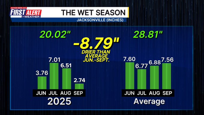
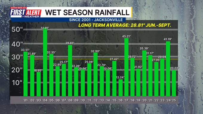
The Northeast Florida/SE Georgia wet season is over (June-September). The wet season had a tendency to sputter at times & was off to a slow start not beginning until June 13th. We then saw a dry spell in early to mid Aug. & again through a good part of Sept. Officially at the N.W.S. located at JIA (Northern Duval) 20.02″ of rain fell which is nearly 9″ below the avg. of 28.81″ & the driest wet season since 2016 (12.24″). In fact, 2003 (18.95″) was the only other wet season with less rainfall than 2025.
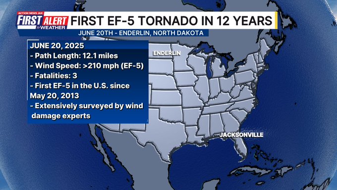
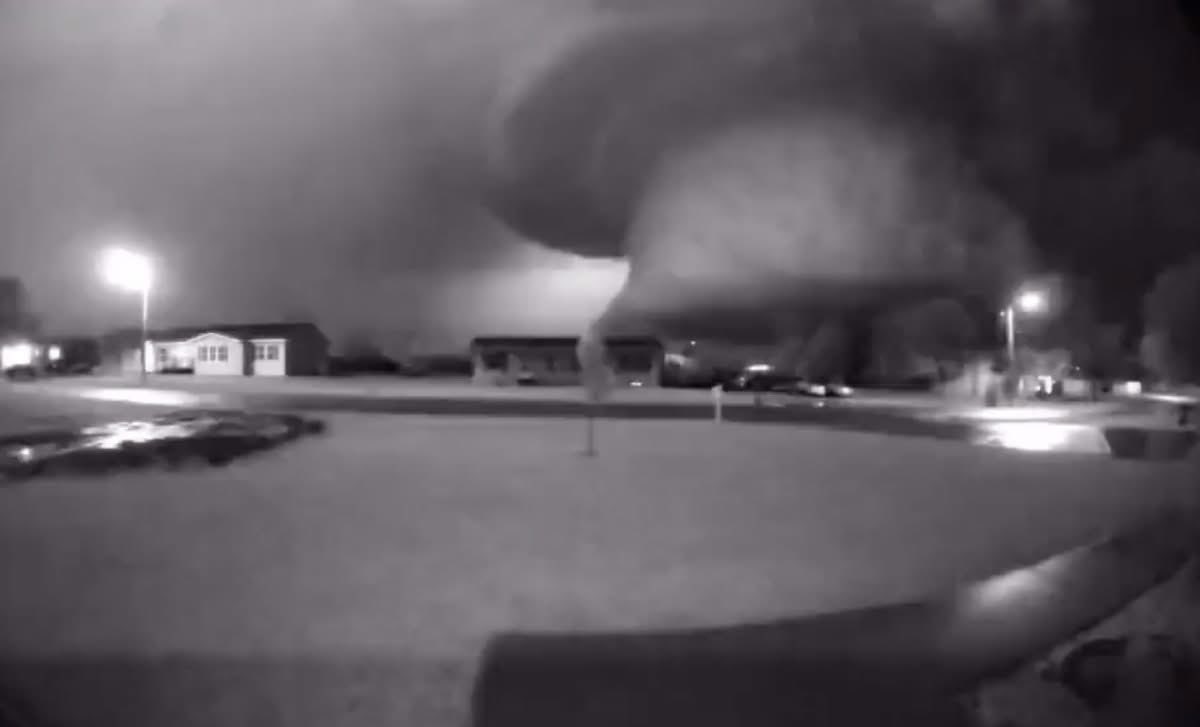
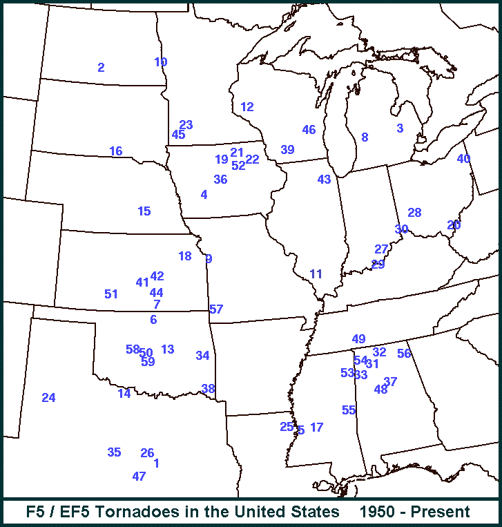
The first EF-5 tornado in the U.S. in 12 years has been confirmed in North Dakota during a June severe weather outbreak. Extensive post storm analysis upgraded what was initially rated an EF-4 tornado to the first EF-5 tornado (210+ mph winds) since Moore, Oklahoma in 2013... & the 60th *documented* EF-5 since 1950. Realize tornadoes are only given an official rating if they do damage of some sort & are investigated by the N.W.S. See the full report from the Grand Forks N.W.S. * here *.
The estimated maximum wind speed of the Enderlin, ND tornado #1 is greater than 210 mph and occurred during the time of the train derailment south of Enderlin, ND. The analysis involved forensic damage wind speed estimates for tipping several fully-loaded grain hopper cars and lofting of tanker cars, including one empty tanker car that was tossed about 475.7 ft (145 m). The maximum wind speed also correlates to the maximum strength on WSR-88D Storm-Relative Velocity data from KMVX. Additional high-end damage indicators that have been reanalyzed and adjusted to include damage to the trees near the Maple River east of Enderlin and damage to the farmstead #2 on Hwy 46. Further analysis of the trees surrounding the Maple River show extensive tree damage throughout the entire river valley with only stubs of large branches or large trunks remaining and debarking with a “sandpapering” effect prevalent. Trees with attached root ball displacements were noted, including one where the original location could not be determined. Wind damage expert analyses helped determine the damage at farmstead #2 to be complete destruction with the foundation considered to be swept clean, and debris swept downwind and scattered. However, issues surrounding the lack of proper anchoring will limit the overall rating in this area. Trees around the farmstead were also debarked, and saw root ball displacements. The National Weather Service in Grand Forks would like to thank Tim Marshall, Jim LaDue, Dr. Connell Miller, Dr. Greg Kopp, Dr. David Sills, and the entire Northern Tornadoes Project at Western University’s Canadian Severe Storms Laboratory team for their assistance.
EF0...WIND SPEEDS 65 TO 85 MPH.
EF1...WIND SPEEDS 86 TO 110 MPH.
EF2...WIND SPEEDS 111 TO 135 MPH.
EF3...WIND SPEEDS 136 TO 165 MPH.
EF4...WIND SPEEDS 166 TO 200 MPH.
EF5...WIND SPEEDS GREATER THAN 200 MPH.
Security cam still image of the EF-5 tornado:
F-5 (before 2007) & EF-5 tornadoes since 1950:
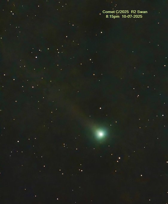
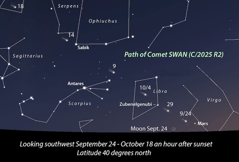
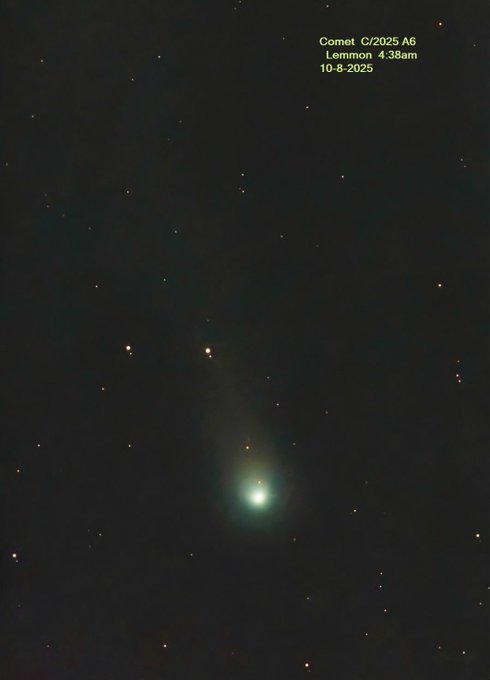
A newly discovered comet - “SWAN” is visible in the western skies right now (as well as Lemmon in the early morning - more details * here *). Look to the west after sunset. Mike Rosset shot the pic below locally from Mandarin of SWAN... & the third image/pic is from Mr. Rosset showing comet Lemmon early in the morning (4:40am Wed., 10/08) but comet Lemmon will be visible in the western evening sky for the last 2 weeks of Oct. into early Nov. & is expected to become brighter:
October night skies (Sky & Telescope):
Oct. 9 (evening): The waning gibbous Moon and the Pleiades rise together. The Moon’s light will overwhelm the scene, but binoculars should help tease out the cluster’s stars.
Oct. 14 (morning): Turn to the east to see a pretty, equilateral triangle with 6½°-long sides formed by the last-quarter Moon, Jupiter, and Pollux.
Oct. 16 (morning): The waning crescent Moon leads Regulus above the eastern horizon by roughly 4°.
Oct. 19 (dawn): The Moon, two days shy of new, accompanies Venus as they rise in the east. The lunar crescent is a bit less than 4° upper right of the planet.
Oct. 20–21 (all night): The Orionid meteor shower is expected to peak. The new Moon should make for favorable viewing conditions.
Oct. 24 (dusk): The waxing lunar crescent hangs about 1½° below Antares, the celestial Scorpion’s smoldering heart, above the southwestern horizon. Observers in Australia and New Zealand will see the Moon occult (cover) the star.
Nov. 1 (dusk): Face southeast to see the waxing gibbous Moon gleaming a bit more than 5° upper right of Saturn. The pair grows closer as the evening wears on. Turn to page 46 for more on this and other events listed here.
Nov. 2 Daylight-saving time ends at 2 a.m. for most of the U.S. and Canada.
Nov. 2 (dawn): Venus and Spica are 3½° apart as they rise above the east-southeastern horizon shortly before sunrise.
Nov. 6 (dusk): The Moon, 1½ days past full, trails the Pleiades by 5½° as they climb in the east-northeast.
Moon Phases
Full Moon October 6 11:48 p.m. EDT (Full Harvest Moon)
Last Quarter October 13 2:33 p.m. EDT
New Moon October 21 8:25 a.m. EDT
First Quarter October 29 12:21 p.m. EDT
Let’s help out our local Feeding Northeast Florida:
Feeding Northeast Florida has been named a finalist in the Land Rover Defender Service Awards!
This award includes a new Land Rover Defender. This powerful tool would help Feeding NE Florida reach all corners of their 12-county service area. You can vote * here * through October 19th.