
Jacksonville, Fl. — THE TROPICS:
***** ALWAYS CHECK & RE-CHECK THE LATEST FORECAST & UPDATES! ****
Tropics threats/impacts for Jacksonville/NE Florida/SE Georgia: None
The Atlantic Basin Overview:
The Atlantic hurricane season is June 1st through Nov. 30th.
(1) A Hurricane WATCH: southern peninsula of Haiti from the border with the Dominican Republic to Port-Au-Prince.... Tropical Storm WATCH for Jamaica.
‘98-L’ - became “Melissa” over the Caribbean Tue. morning. The Caribbean is a climatologically favored area as we move through the late Atlantic hurricane season. The development stems from a late season African tropical wave that rolled off Africa last week. The wave had been speeding underneath the strong Bermuda high over the Central & Eastern Atlantic - one of the few waves this hurricane season that has taken the “low road”. The wave axis moved quickly across the Central Lesser Antilles through Sunday night with gusty squalls of wind & rain but has dramatically slowed over the Caribbean as it encounters an area of weak steering currents. Though moderate to strong shear has kept Melissa “in check” so far... overall conditions will be favorable for strengthening with - most likely - an eventual movement of some semblance north or northeastward. The center of Melissa may very well jump around from time to time based on strong pulses of intense convection until the tropical cyclone can become well organized & the low level center aligned with the mid level center. This kind of pulsing & slow organization is classic of late season tropical cyclones in or near the Caribbean (Wilma in 2005 pops into my mind immediately though there are many other examples). In the end... I suspect Melissa will become a “major” (Cat. 3+) hurricane.
Model consistency - as one would expect in the longer range & without the system fully developed - has not been good but heads-up across the Caribbean! Both the European model & GoogleDM backed off for a couple days late last week but are now trending stronger again but with significant differences on when Melissa comes out of the Caribbean. The GFS model has been pretty consistent on a strong hurricane that moves northeast earlier & far to the east of the U.S. before slowing, possibly stalling over the far SW Atlantic awaiting the next strong trough next week that then accelerates Melissa to the northeast. There are still models - most notably the European & Canadian & now GoogleDM that are more west & much slower. How far west & how quickly there is a turn north/northeast may be at least partially related to how quickly the wave deepens. Weaker - more west... stronger - more north(east). The European model is more west & much slower before finally turning a powerful hurricane rather quickly northeast next week which would impact at least some of the Greater Antilles & possibly Puerto Rico. The greatest impacts *as of right now* appear to be pointed at Jamaica, Cuba & Hispaniola.
The ultimate path & forward speed will largely depend on the strength & positioning (depth) of an upper level trough moving into the U.S. through the end of this month - a mainstay of this ‘25 Atlantic hurricane season. This trough may/should also continue to be the U.S. “lucky charm” helping to keep Melissa east of the U.S. but no guarantees yet on how this set-up plays out. The trough will dig into first the Central then Eastern U.S. If this week’s trough over the far W. Atlantic misses Melissa - which appears increasingly likely - then Melissa will wait on next week’s trough to possibly get captured & pulled northeast. This evolving upper level weather pattern will be complex & almost certainly will result in changes in the forecast in the coming days. But indications remain *so far* for a tropical cyclone that stays south & east of Florida, but I cannot emphasize enough that exactly how Melissa plays out - moves - is still highly uncertain.


GoogleDM has slowly trended west over the next few days before shooting northeast similar to the European model now:
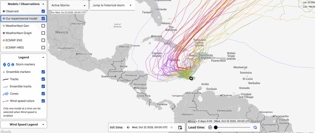
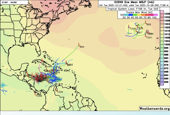
Forecast model ensembles are in two “camps” - one that’s more northeast with an earlier turn vs. a languishing Melissa over the Central, even Western Caribbean:
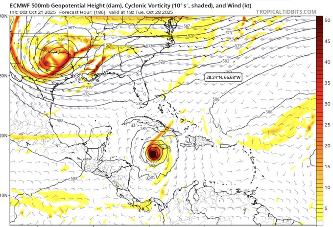
The upper level forecast from the European model for next Tue., Oct. 28 showing a deep trough digging over Texas then should move east & should have a role in Melissa’s movement either over the Caribbean or SW Atlantic depending on exactly where Melissa is located (keep in mind some models are further northeast vs. European for next week):
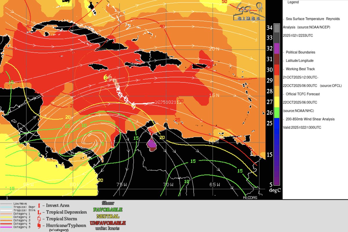
Very warm water temps. alone do not guarantee a “major” storm... other ingredients need to be favorable too. Right now shear out of the west at 20-30 mph has slowed Melissa’s organization:


‘Velocity potential anomalies’ below. shows “Rising” air (green lines) equates with an uptick in overall convection. With rising air, conditions are generally more favorable for tropical development. Where there are brown lines, the air is generally sinking & is often less conducive to tropical cyclones (though not impossible to have development).

The “Buresh Bottom Line”: Always be prepared!.....First Alert Hurricane Preparation Guide... City of Jacksonville Preparedness Guide... Georgia Hurricane Guide.
STAY INFORMED: Get the * FREE * First Alert Weather app
FREE NEWS UPDATES, ALERTS: Action News Jax app for Apple | For Android
WATCH “Preparing for the Storm”
WATCH “The Ins & Outs of Hurricane Season”
READ the First Alert Hurricane Center “Preparation Guide”
LISTEN “First Alert Weather: Preparing for the Storm”
Federal Alliance for Safe Homes (FLASH) * here *.
REMEMBER WHEN A TROPICAL STORM OR HURRICANE IS APPROACHING: Taping windows is *not* recommended & will not keep glass from breaking. Instead close curtains & blinds.
Realize the forecast cone (”cone of uncertainty”) is the average forecast error over a given time - out to 6 days - & *does not* indicate the width of the storm &/or where damage might occur.

The map below shows the *average* time for a tropical wave coming off Africa to travel west & northwest. Only about 1 in 5 tropical waves - on average - become a tropical cyclone of some sort (depression/storm/hurricane):


Water vapor loop (dark blue/yellow is dry mid & upper level air):


October Atlantic tropical cyclone origins:

Averages below based on climatology for the Atlantic Basin for October:

Wind shear (red - strong shear; green - low shear). Shear is typically strong to start the hurricane season:


Saharan dust spreads west each year from Africa driven by the prevailing winds (from east to west over the Atlantic). Dry air = yellow/orange/red/pink. Widespread dust is indicative of dry air that *can* interfere with the development of tropical cyclones. However, sometimes “wanna’ be” waves will just wait until they get to the other side of - or away from - the dust plume then try to develop if other conditions are favorable (we saw this with Beryl & Debby last year). It’s my personal opinion that there is way too much “hoopla” about the presence of Saharan dust & how it relates to tropical cyclones. In any case, the peak of Saharan dust typically is in June & July, & we are indeed seeing a large “blobs” of Saharan dust over the Central & Eastern Atlantic that’s thinning with westward extent but enough of it to make for hazy skies across the Caribbean & - at times - across parts of Florida.

2025 names..... “Nestor” is the next name on the Atlantic list (names are picked at random by the World Meteorological Organization... repeat every 6 years). Historic storms are retired [Florence & Michael in ’18... Dorian in ’19 (the last time this year’s list was used) ... Laura, Eta & Iota in ‘20 ... Ida in ‘21 ... Fiona & Ian in ‘22... no names were retired in ‘23 for the first time since 2014... & Beryl, Helene & Milton last year in 2024]). The WMO decided - beginning in 2021 - that the Greek alphabet will be no longer used & instead there will be a supplemental list of names if the first list is exhausted (has only happened three times - 2005, 2020 & 2021). The naming of tropical cyclones began on a consistent basis in 1953. More on the history of naming tropical cyclones * here *.

Hurricane season climatology:


East Atlantic:


Mid & upper level wind shear (enemy of tropical cyclones) analysis (CIMMS). The red lines indicate strong shear:

Water vapor imagery (dark blue indicates dry air):

Deep oceanic heat content over the Gulf, Caribbean & tropical Atlantic. Brighter colors = warmer temps.:

Sea surface temps.:

Sea surface temp. anomalies:

SE U.S. surface map:

Surface analysis centered on the tropical Atlantic:

Surface analysis of the Gulf:

Caribbean:

Atlantic Basin wave period forecast for 24, 48, 72 & 96 hours respectively:


This past spring I visited the west coast of Florida - from Cedar Key to Tampa Bay - to see how the area is recovering from the very rough ‘24 hurricane season namely Helene & Milton:
East & Central Pacific:


Central Pacific:

Hawaii satellite imagery:


West Pacific:
Global tropical activity:


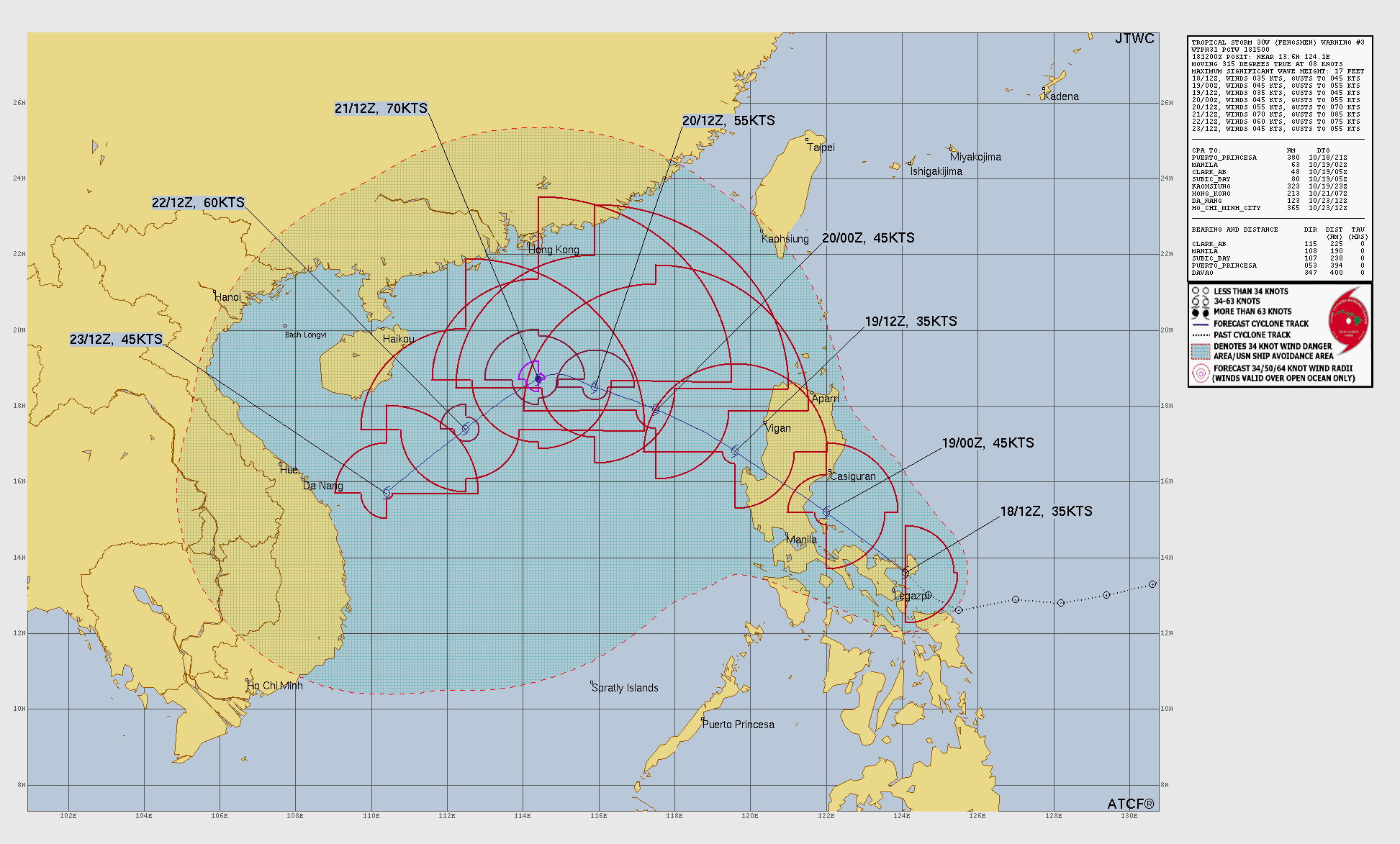
“Fengshen”:
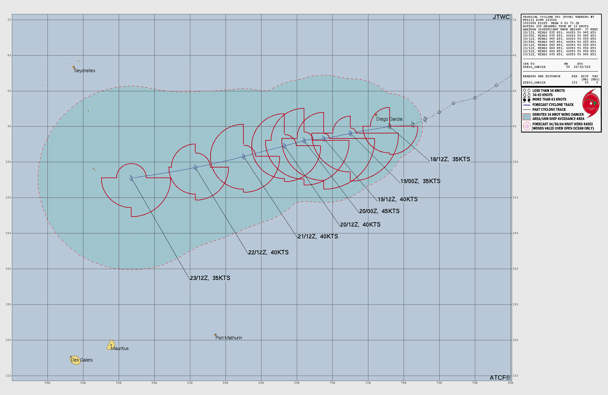
“Chenge”:


Cox Media Group


